Improved Geologic Map of Arizona Online Map Service
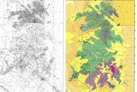
The AZGS GIS-IT team recently enhanced and launched an improved online geologic map of Arizona (https://geomapaz.azgs.arizona.edu/). The geology and unit pop-up descriptions are identical to that of M-35, Geologic Map of Arizona by Richard and others (2000).
This refreshed online map has several new features. The underlying US Geological Survey topographic base map includes roads and communities to facilitate finding the area of interest. To select the base map and to toggle ‘Geologic Units’, ‘Faults’ and ‘Geologic Maps’, select the layers icon in the upper right hand corner of the map. The ‘Geologic Maps’ function will draw the footprints of about 120 Digital Geological Maps (DGM). Each footprint is accompanied by a pop-up with the map title, map description, and link to that map product at the AZGS Document Repository.
Geologic maps of the DGM series are typically accompanied by:
• a high resolution PDF;
• GeMS geodatabase;
• Google Earth -KMZ;
• open-source version of the gisdata;
• simplified version of the geodatabase;
• and geopackage.

As new DGM map products are released or older DGMs are revised to include the geodatabase, their footprint will be added to the online geologic map.
All AZGS’ DGM map products can be found at AZGS DGM Geologic Map Series. For other geologic map products - Contributed Maps, Open-File Reports, Miscellaneous Maps, Map Series, Digital Maps, and Digital Information - visit the AZGS Online Document Repository.
Citations
Richard, S.M., 2000, Geologic Map of Arizona. Arizona Geological Survey Map-35, 1,000,000 map scale. http://repository.azgs.az.gov/uri_gin/azgs/dlio/1705 This link includes a Google Earth KMZ file.