New Geologic Bedrock Map of Oceanic Peridotite at Cemetery Ridge, southwest Arizona
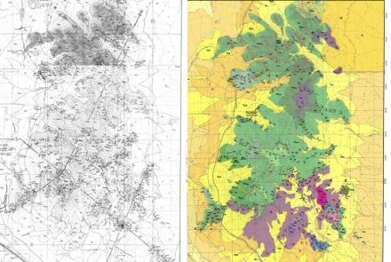
Cemetery Ridge in southwestern Arizona is a rare and important example of a far-inland subduction complex. A new bedrock geologic map by Jon Spencer (AZGS, retired) and Gordon Haxel (USGS, retired) elucidates the geographic distribution of oceanic peridotite, chiefly harzburgite and serpentinite, in the Late Cretaceous Orocopia Schist. The map is accompanied by a page of citations of earlier work.

Haxel and others (2015) first documented the exposure of peridotite-bearing, Orocopia Schist at Cemetery Ridge. They identified the ridge as the eastern-most expression of the Chocolate Mountains anticlinorium which extends for more than 200 km from western California to Cemetery Ridge in western Arizona. The complex geochemistry of the serpentinized peridotite cloud its origin, but Haxel and others hypothesized four tectonic settings where the peridotite could have originated in a low-angle continental margin subduction system beneath southern California and southwest Arizona – see their Figure 17 for explanation.

Spencer and Haxel's (2021) chief objective with this map is to further research in understanding the tectonic processes involved in exhuming and exposing this subduction complex at the surface.
From the map explanation of Spencer and Haxel (2021) the Orocopia Schist (Kos) is a, “Garnet-bearing biotite quartzofeldspathic schist derived from arkosic-wacke turbidite sandstone, with minor amphibolite schist (metabasalt) and ferromanganiferous metachert and siliceous marble (Haxel et al., 2021). Porphyroblasts of bluish-gray to black graphitic plagioclase are a hallmark, characteristic of Orocopia Schist generally. Contains tectonic blocks of peridotite and pyroxenite—harzburgite, olivine orthopyroxenite, and serpentinite after dunite. Metasomatic reactions between ultramafic rocks and host quartzofeldspathic schist have converted some schist to widespread porphyroblastic actinolite-albite gneiss (“spotted gneiss”). Actinolite veins and pods also are common and were first identified by Wilson (1933)."
Citations
- Haxel, G.B., Jacobson, C.E., and Wittke, J.H., 2015, Mantle peridotite in newly discovered far-inland subduction complex, southwest Arizona: Initial report: International Geology Review, v. 57, 871–892.
- Spencer, J.E. and Haxel, G.B., 2021, Compilation Bedrock Geologic Map of Cemetery Ridge, La Paz and Yuma Counties, southwest Arizona. Arizona Geological Survey Contributed Map CM-21-A, 1 plate - 1:48,000.
- Wilson, E.D., 1933, Geology and mineral deposits of southern Yuma County, Arizona: Arizona Bureau of Mines Bulletin, 134, 236 p.