Transforming 33 Analog Geologic Maps to Digital Map Products
During Fall 2022, AZGS will release 33 digital map products derived from analog geologic maps published before the advent of digital geodatabases. Prior to the 2000s, the Arizona Geological Survey and its predecessor agencies (e.g., Arizona Bureau of Mines) produced analog geologic map products, i.e., paper geologic maps. With financial support from the National Geological and Geophysical Data Preservation Program, UArizona interns, mentored by AZGS staff, chiefly Andrew Zaffos, Carson Richardson, and Haley Snellen, are digitizing the analog maps and adding geodatabases to enhance the functionality of the map products.
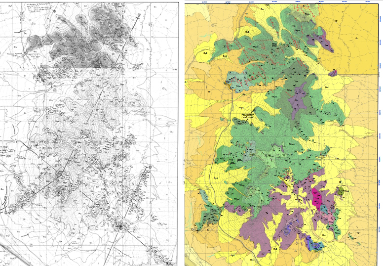
By way of example, Open-File Report 95-10 released in 1995, was digitized and released as Digital Geologic Map 155 – see figure. All freshly digitized geologic maps will include colored PDF geologic map plate(s), GeMS Geodatabase, geopackage, and a Google Earth-KMZ file.

The final digital map products – listed below - will be uploaded to the AZGS Document Repository. Follow AZGS Facebook or Twitter accounts for digital map release alerts. The original geologic map will be available at the Document Repository until the digital version is complete; the original version will then be archived offline.
This is the first of at least two major releases of AZGS analog geologic maps. In 2023, about 30 analog geologic maps are in the queue to be digitized and outfitted with geodatabases.
Caveat: The DGM maps are digital reproductions of an original analog geologic map of the Arizona Geological Survey. Financial support was provided by the Arizona Geological Survey (AZGS) and the U.S. Geological Survey under STATEMAP, program contract #98HQAG2064. No new field mapping was conducted. The views and conclusions contained in this document are those of the authors and should not be interpreted as necessarily representing the official policies, either expressed or implied, of the U.S. Government.
|
Fresh Release Year |
Map Name |
Original Map Code |
New Map Code |
|
2021-2022 |
Florence Junction |
OFR 95-10 |
|
|
2021-2022 |
Cholla Tank and Hoodoo Wash |
OFR 96-24 |
|
|
2021-2022 |
Picacho Peak and Mountains |
OFR 99-18 |
|
|
2021-2022 |
Oracle Junction |
OFR 00-04 |
|
|
2021-2022 |
Oracle |
OFR 00-05 |
|
|
2021-2022 |
Palomas |
OFR 94-09 |
|
|
2021-2022 |
Goldfield |
OFR 95-09 |
|
|
2021-2022 |
Mormon Flat Dam |
OFR 97-14 |
|
|
2021-2022 |
Horse Mesa Dam |
OFR 97-15 |
|
|
2021-2022 |
Picketpost Mountain |
OFR 95-15 |
|
|
2021-2022 |
Kofa Mountains |
OFR 96-03 |
|
|
2021-2022 |
Apache Junction |
OFR 96-08 |
|
|
2021-2022 |
Picacho Basin Plate1 |
OFR 90 02 |
|
|
2021-2022 |
Picacho Basin Plate2 |
OFR 90 02 |
|
|
2021-2022 |
Picacho Basin Plate3 |
OFR 90 02 |
|
|
2021-2022 |
Picacho Basin Plate4 |
OFR 90 02 |
|
|
2021-2022 |
Picacho Basin Plate5 |
OFR 90 02 |
|
|
2021-2022 |
Picture Mountains |
OFR 99-23 |
|
|
2021-2022 |
Copper Mountains |
OFR 99-24 |
|
|
2021-2022 |
Greenback Creek |
OFR 99-10 |
|
|
2021-2022 |
Windy Hill |
OFR 99-12 |
|
|
2021-2022 |
Lincoln Ranch Basin |
OFR 86-02 |
|
|
2021-2022 |
Gila Bend Mountains |
OFR 97-08 |
|
|
2021-2022 |
Humboldt Mountains |
OFR 98-11 |
|
|
2021-2022 |
New River Mesa |
OFR 98-12 |
|
|
2021-2022 |
Samaniego Hills |
OFR 99-17 |
|
|
2021-2022 |
Tank Mountains |
OFR 94-08 |
|
|
2021-2022 |
Sawtooth Mountains |
OFR 99-16 |
|
|
2021-2022 |
Ninety-Six Hills-Plate 1 |
OFR 99-20 |
|
|
2021-2022 |
Ninety-Six Hills-Plate 2 |
OFR 99-20 |
|
|
2021-2022 |
Ninety-Six Hills-Plate 3 |
OFR 99-20 |
|
|
2021-2022 |
Ninety-Six Hills-Plate 4 |
OFR 99-20 |
|
|
2021-2022 |
Southern Roskruge Mountains |
OFR 00-06 |


