
Notes on the Cretaceous and Laramide of the Colorado Plateau
The text below is taken directly from Jon Spencer’s introduction to this posthumous release of William R. Dickinson notes and illustrations on the Cretaceous and Laramide of the Colorado Plateau.
"William R. Dickinson was in the process of preparing a comprehensive publication on the Mesozoic stratigraphy and tectonic setting of the Colorado Plateau when he died abruptly while on a geoarchaeological expedition to Tonga (Spencer, 2016). The book was largely written and the completed chapters were published posthumously by the Geological Society of America (Dickinson, 2018). Dickinson had drafted figures and written figure captions and some text for three additional chapters that were not included in GSA Special Paper 533. The topics of those three chapters are as follows:
• Lower Cretaceous Cedar Mountain – Burro Canyon deposystem
• Upper Cretaceous Mancos – Mesaverde deposystem
• Laramide Orogeny
The preliminary text and drafted figures for these uncompleted chapters are included in this Contributed Report which is made available by the Arizona Geological Survey in the hope that it might be useful to those researching the Cretaceous and Laramide geology of the Colorado Plateau."
Illustration Captions
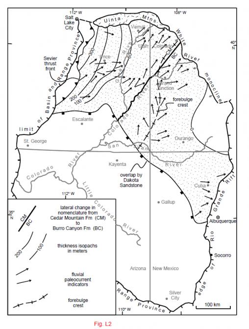
Figure L2. Areal distribution (stippled), thickness (isopachs), and sediment dispersal (paleocurrents) of the Lower Cretaceous Cedar-Burro deposystem (Cedar Mountain and Burro Canyon Formations and inferred equivalents). The Jackpile Sandstone Member of Morrison Formation (Owen et al., 1984) is treated as equivalent to the Burro Canyon Formation after Aubrey (1992) and Dickinson and Gehrels (2008b).
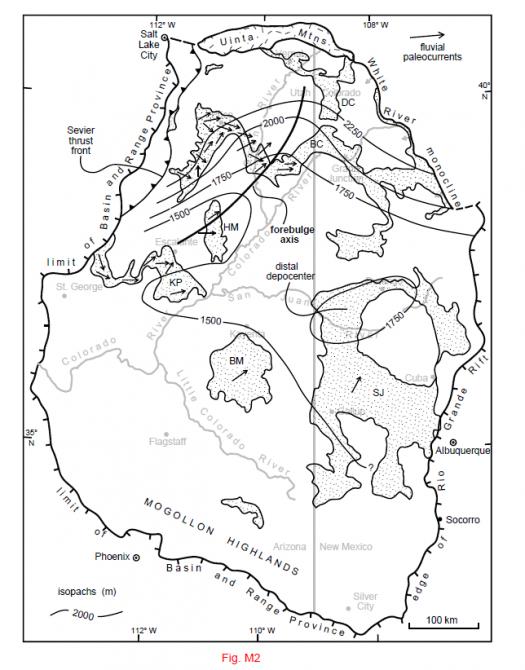
Figure M2. Outcrop belt (stippled) and reconstructed isopachs of pre-Maastrichtian (pre-Laramide) Upper Cretaceous strata forming the Mancos-Mesaverde deposystem on the Colorado Plateau (Mancos Shale, Mesaverde Group, and equivalent strata). Note that the isopach spacing is arithmetic, unlike the geometric spacing of isopachs on other paleogeographic maps, and that long segments of isopach lines are inferred from thicknesses recorded only around the periphery of the Colorado Plateau (BC–Book Cliffs, BM–Black Mesa, DC–Douglas Creek arch, HM– Henry Mountains, KP–Kaiparowits Plateau, SJ–San Juan basin). Paleocurrents are plotted only for fluvial and fluviodeltaic strata, and not for equivalent marine strata exposed to the east and northeast.
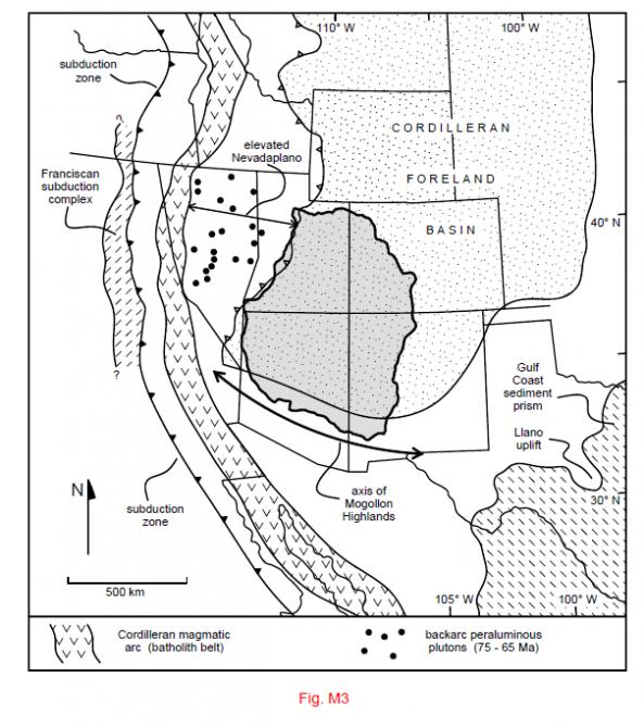
Figure M3. Regional setting of the Cretaceous Cedar-Burro and Mancos-Mesaverde deposystems of the Colorado Plateau (shaded) at the southwestern corner of the Cordilleran foreland basin (stippled) near the tectonic syntaxis between the Sevier thrust belt and the Mogollon highlands. Geotectonic relations along the Cordilleran continental margin after Dickinson (2008, 2009, 2011, 2013b).
Figure N1. Principal Laramide structural features of the Colorado Plateau adapted after Kelley (1955), Krantz (1989), Cather (2004), and Davis and Bump (2009). Monoclines: CRm–Comb Ridge, ECm–Echo Cliffs. EDm–East Defiance, EKm–East Kaibab, Hm–Hogback, RLm–Red Lake, SRCm–Salt River Canyon, SRRm–San Rafael Reef; TCm–Tsegi Canyon, WFm–Waterpocket Fold.
Posted 29 May 2018 (MC)