I17-Landslide Post - Part IV: Hy179 and I17 on the western edge of the Mormon Mountain volcanic field
This is the fourth and final post reporting on AZGS geoscientists as they map and investigate landslides along Interstate Highway 17 (I-17) from Anthem (25 miles north of Phoenix) to Flagstaff. This is a preliminary report and has not been reviewed for AZGS editorial standards. The AZGS will release a report with data, digital maps, and final results later this year.
Introduction. I-17 is the chief route between Phoenix in central Arizona and Flagstaff in northern Arizona. Each day more than 50,000 cars (> 18,250,000 cars annually) traverse the Anthem Way - Sunset Point segment. The I-17 corridor winds through hills, mountains, river valleys, and plateaus, slicing through fractured and weathered rocks. Landslides and rock falls potentially threaten I-17 from the Agua Fria River north to the Mogollon Escarpment, 25 miles south of Flagstaff. Over the next several years the Arizona Dept. of Transportation (ADOT) plans to spend ~$300 million to expand and improve I-17 between Anthem and Sunset Point. AZGS’s I-17 landslide assessment project will provide basic data that ADOT can use as part of designing and constructing highway improvements.
With funds from the Arizona Dept. of Emergency and Military Affairs (DEMA), AZGS Research Scientists J.P. Cook and B.F. Gootee are surveying a 15-mile-wide strip centered on the current route of I-17 from Anthem to Flagstaff – a distance of ~100 miles, to identify landslides. The two are using moderately detailed topographic data derived from 2017 aerial orthophotography in a GIS platform, and field investigations aided by drone surveys and analysis.
Results from this study will be integrated with the more than 6,300 landslides in the Arizona Statewide Landslide Database (AzSLID) compiled by AZGS geoscientists (Youberg and others, 2015). The Natural Hazards in Arizona Viewer includes a landslide theme portraying the AzSLID data.
AZGS at work for Arizona series presents landslides along the I-17 corridor between Anthem and Flagstaff, Arizona. The first three parts are presented below. In this series we present part IV: Landslides encountered ascending the eastern slope of Verde Valley.
Part I. Identifying landslide deposits and hazards on the I-17 Corridor
Part II. Landslides of Black Canyon City and Sunset Point Visitor's Center
Part III. Landslides of the Black Hills and the Verde Valley
Part IV: Landslides encountered ascending the northern slope of Verde Valley
Landslide masses make up a prominent part of the landscape 11 miles north of Camp Verde along I-17, and to the north, northeast and southeast of the I-17 - AZ 179 interchange. Weir and others (1989) mapped a pod of landslides along the frontal lobe of ‘ramp’ basalt lava flows erupted from the late Miocene-Pliocene Mormon Mountain volcanic field. The neighboring hills and gullies are sparsely populated by juniper (Juniperus monosperma) common to the western U.S. and Arizona.
The Mormon Mountain field comprises basaltic sheet lavas and shields, scoria cones and small associated flows, and the two major silicic centers of Mormon Mountain and Hackberry Mountain (Holm and Ulrich, 1974 ).
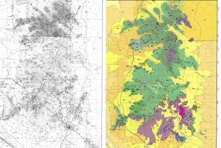
Using aerial photogrammetry, UAV drone imagery (VIDEO), and ground surveys, AZGS geoscientists refined the areal extent of landslide deposit mapped by Weir and others (1989) and DeWitt and others (2008) and identified several previously unmapped deposits. There are 19 discrete landslide deposits along a 12-mile-long arc at the snout of a broad mesa comprising basalts of the Mormon Mountain volcanic field (Figure 1). Apparently, landsliding propogated at the junction of dense, competent basalt and underlying, weaker sedimentary rocks of the Miocene to Pliocene Verde Formation.
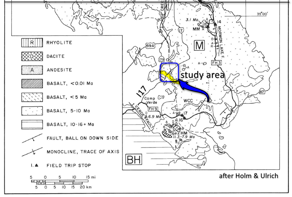
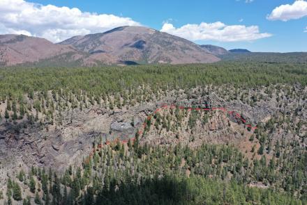
Figure 2 illustrates the collapse of the snout of the basalt lava mesa above older sedimentary rocks. The prominent corrugated and hummocky feature comprising the landslide surface suggests a late Tertiary to Pleistocene age. No evidence of recent (historic movement) was observed, but future collapse along the basalt escarpment cannot be ruled out. The I-17 – AZ 179 landslides include both translational and rotational elements.
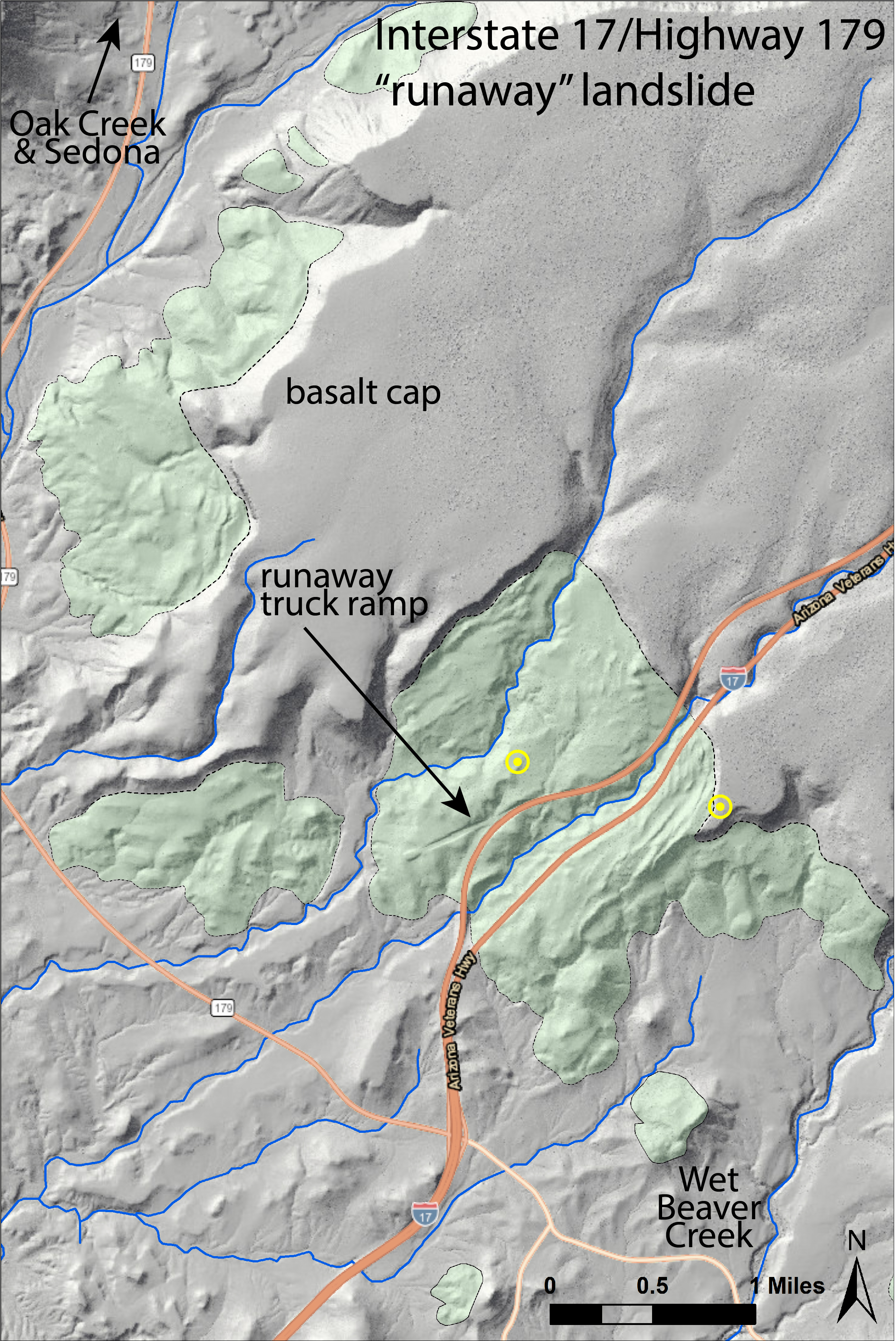
Figure 3 presents the distribution and the areal extent of landslides that form a discontinuous arc about the basalt mesa. Table 1 lists the enumerated slide deposits with their respective perimeter lengths and areas in miles and square miles. The aggregate perimeter is approximately 35 miles with an aggregate area of 6.1 square miles.
For a birds-eye view of the 'Runaway' landslide, the largest of the 19 landslides in the I-17 - AZ 179 area: UAV Video by B. Gootee.
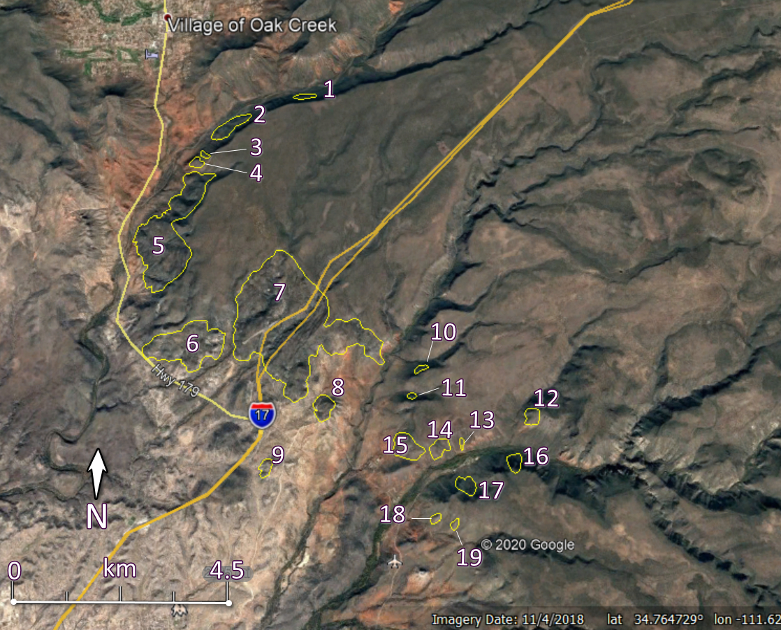

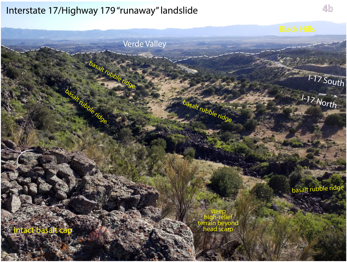
Table 1. Approximate landslide perimeter, lengths and areas derived from ArcGIS.
|
Landslide |
Perimeter (m) |
Area (sq. m) |
Perimeter (ft) |
Area (sq. miles) |
|
1 |
1536 |
128319 |
5038 |
0.05 |
|
2 |
2470 |
316920 |
8102 |
0.12 |
|
3 |
976 |
45412 |
3201 |
0.02 |
|
4 |
1282 |
101284 |
4205 |
0.04 |
|
5 |
11241 |
3653096 |
36870 |
1.41 |
|
6 |
6508 |
1823741 |
21346 |
0.70 |
|
7 |
16017 |
7946944 |
52536 |
3.07 |
|
8 |
2164 |
297809 |
7098 |
0.11 |
|
9 |
1497 |
130818 |
4910 |
0.05 |
|
10 |
969 |
51070 |
3178 |
0.02 |
|
11 |
651 |
30483 |
2135 |
0.01 |
|
12 |
1429 |
137696 |
4687 |
0.05 |
|
13 |
702 |
21478 |
2303 |
0.01 |
|
14 |
1742 |
176975 |
5714 |
0.07 |
|
15 |
2535 |
417306 |
8315 |
0.16 |
|
16 |
1482 |
151974 |
4861 |
0.06 |
|
17 |
1738 |
189834 |
5701 |
0.07 |
|
18 |
889 |
56093 |
2916 |
0.02 |
|
19 |
788 |
42004 |
2585 |
0.02 |
|
TOTALS |
56616 |
15719256 |
185700 |
6.07 |
Select Resources
- Arizona Geological Survey, 2020, Natural Hazard in Arizona Viewer, landslide theme.
- Arizona Public Media, 2019, Landslide Database to Shape Arizona I-17 Expansion Project. Associated Press (16 Aug. 2019),
- DeWitt, Ed, Langenheim, Victoria, Force, Eric, Vance, R.K., Lindberg, P.A., and Driscoll, R.L., 2008, Geologic map of the Prescott National Forest and the headwaters of the Verde River, Yavapai and Coconino Counties, Arizona: U.S. Geological Survey Scientific Investigations Map 2996, scale 1:100,000, 100-p. pamphlet. https://pubs.usgs.gov/sim/2996/
- Holm, R. F., and Ulrich, G. E., 1987, Late Cenozoic volcanism in the San Francisco and Mormon volcanic fields, southern Colorado Plateau, Arizona: in Davis, G.H. and Vanden Dolder, E.M. (eds.), Geologic diversity of Arizona and its margins: Excursions to choice areas: Arizona Bureau of Geology and Mineral Technology Special Paper 5, p. 85-94.
- Weir, G.W., Ulrich, G.E., and Nealy, L.D., 1989, Geologic map of the Sedona 30' X 60' quadrangle, Yavapai and Coconino Counties, Arizona. US Geological Survey Miscellaneous Investigation Series Map I-1896, 1:100,000.
Contributed by B. Gootee, J. Cook, M. Conway and P. Pearthree.