
ML 3.6 Earthquake near Duncan/Safford in southeastern Arizona
At 10:01 a.m. on 27 April 2019, Duncan, Arizona and environs were rocked by an ML 3.6 earthquake. AZGS Research Geoscientist J.Y. Ben-Horin filed this preliminary report.
Preliminary Report: The Duncan/Safford area near the northern Peloncillo Mountains of southeastern Arizona experienced a sequence of relatively shallow earthquakes, with the largest being an ML 3.6 (ML – local magnitude) at 10:01 am MST on 27 Apr 2019 (Figure 1). Local reports note moderate to light shaking (courtesy of USGS's 'Did you feel it'). There were no reports of injuries or damage.
By mid-afternoon on 27 April, there were at least two additional measurable quakes that were located just south of the ML 3.6, Md 2.4 at 11:46 a.m. and Md 2.0 (Md – duration of shaking) at 11:55 a.m. MST. In addition, there were 10 smaller quakes that range in size, but are generally below Md2.0. The depth to the focus (rupture point) of the earthquake was less than 5km, which is considered shallow.
(NOTE: On 4/30, we added another image illustrating the aftershock activity in the wake of the ML 3.6 event; figure provided by AZGS Research Geologist J.Y. Ben-Horin.)
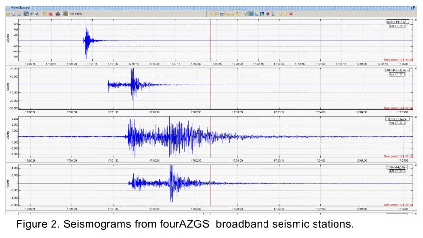
Seismometers of the AZGS’ Arizona Broadband Seismic Network recorded the events (Figure 2).
Warning - Residents and civil authorities of Greenlee County and environs; it’s likely that small magnitude aftershocks will occur in the Duncan area for days or weeks. Most will probably go unfelt. A larger magnitude event could still occur. In the event of severe ground shaking, residents are advised to “Drop, Cover and Hold on” (Conway and Young, 2012).
Historic earthquake activity in eastern Arizona
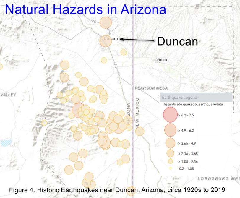
There are a number of Quaternary faults in southeastern Arizona and the area has experienced historic earthquakes. (The Quaternary Period extends from 2.58 Mya to the present.)
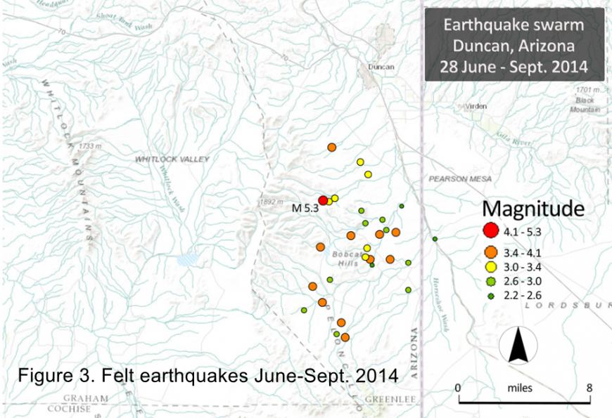
2014 – 2015. At approximately 10 pm on June 28th, 2014, a magnitude 5.2 earthquake rocked Duncan, AZ, (Figure 3). Ground shaking was strong and caused great consternation in the Duncan area. The event was felt throughout southeastern Arizona, including Tucson and Phoenix (Young and Pearthree, 2014; Allison, 2014). The earthquake focus originated at a depth of ~ 7 km (4.4 miles); there were no signs of ground rupture or fissuring.
Minor damage was reported in Duncan and Safford; cracks in concrete structures and at least one home foundation, several manufactured homes were knocked off their foundations, and glassware flew out of cupboards. This was the largest earthquake to occur in southeastern Arizona and southwestern New Mexico in 75 years.
The main event was followed by nearly two dozen smaller magnitude but felt aftershocks (Figure 3). The last felt aftershock occurred more than one year after the 28 June 2014 main event. In total, hundreds of aftershocks were recorded; the vast majority were less than 2.0 M and were not felt. AZGS research scientist J.Y. Ben-Horin deployed six temporary seismic stations to monitor aftershocks.
2010 - 2012. In May 2010 and October 2012, small microseismic swarms, with individual events ranging from M2.0 to M4.1, occurred about 45 miles north-northeast of Duncan, in the Morenci-Clifton area of northern Greenlee County.
1938 - 1939. An earthquake sequence along the New Mexico – Arizona border region included an M 5.5 earthquake (9/7/1938) and three M 4.5 aftershocks; the final large aftershocks occurred more than 9 months after the main event. Seismic instrumentation in the United States was sparse, so the earthquakes are likely not located accurately and the record of aftershocks is incomplete.
1887. The largest historical earthquake in the southeastern Arizona – southwestern New Mexico – northern Mexico region was the M 7.5M event in May 1887 on the Pitaycachi fault of northern Sonora, Mexico, about 25 miles south of Douglas, Arizona. The ground surface was ruptured for nearly 60 miles (100 km) producing a fault scarp with a maximum relief of 4 m (12 ft). It was felt throughout northern Mexico – more than 50 people were killed as buildings collapsed – and the Arizona Territory. This is considered the largest magnitude earthquake likely to occur in the southeastern Basin and Range Province.
References
Allison, M.L., 2014, AZGS news release on Duncan M5.2 earthquake. Arizona Geology Blog, 29 June 2014.
Conway, F.M. and Young, J., 2012, Arizona is earthquake country. Arizona Geological Survey Down-to-Earth (DTE) 21, 44 p.
Great Arizona ShakeOut web resources & registration site
Natural Hazards in Arizona Viewer: Online interactive viewer hosting earthquake epicenters & Quaternary faults, earth fissures, fires, and floods. (A joint product of AZGS and DEMA)
Pearthree, P.A., 1986, Late Quaternary Faulting and Seismic Hazard in Southeastern Arizona and Adjacent Portions of New Mexico and Sonora, Mexico. Arizona Geological Survey Open File Report, OFR-86-08, 22 p.
Young, J. and Pearthree, P.A., 2014, Duncan M5.3 Earthquake of June 2014 and Temporary Seismic Network Deployment. Arizona Geology e-Magazine, Oct. 2014.
Posted 29 Apr 2019 | AZGS Staff