New mapping of the Blythe 7 ½’ quadrangle records the pre- and post-dam era history of transformation of the Lower Colorado River
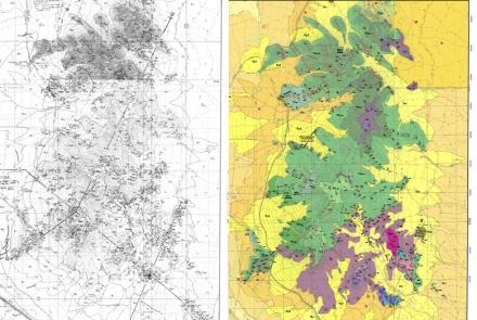
The Blythe 7 ½' Quadrangle straddles the Colorado River, including the City of Blythe, in western Arizona and eastern California. Collaborative mapping by the US Geological Survey and the Arizona Geological Survey illustrates the evolving geomorphology and deposits of a major river system before and after major dams were constructed upstream.
This geologic map spans about 60 percent of the width of the Holocene floodplain and valley floor of the lower Colorado River (almost entirely in California) and the adjacent lower piedmont on the Arizona side of the river. The Arizona portion of the map includes extensive exposures of the earliest through-flowing Colorado River deposits – early to middle Pliocene Bullhead Alluvium, late Pleistocene Colorado River terrace deposits – Chemehuevi Formation, and Pliocene to Holocene tributary deposits.
The most unique aspect of this map is its detailed depiction of late Holocene deposits on the Colorado River floodplain. The floodplain map was developed using archival data sources including notes and maps from early river expeditions, early cadastral and topographical surveys, and a series of historical aerial photographs. These various data sources allow us to ‘look beneath’ anthropogenically-altered floodplain and tightly controlled channel and of the modern environment, depicting the detailed geology and geomorphology of an extremely dynamic floodplain environment, with frequent changes in channel sizes and positions, prior to dam construction (see photos). Detailed well logs combined with geologic mapping were used to construct the subsurface extent of Holocene deposits in cross sections. Combined with surficial mapping of the floodplain and radiocarbon ages of the Holocene deposits, these data were used to formally define and formalize the Blythe Alluvium as the youngest lithostratigraphic unit of river deposits in the lower Colorado River corridor.
The Blythe, AZ-CA 7.5' sheet (AZGS DGM-124), includes 2 map sheets, a 45p. report, and GIS Data that can be downloaded from the AZGS Document Repository at:
http://repository.azgs.az.gov/uri_gin/azgs/dlio/1932
Citation: Block, D., Gootee, B.F., House, P.K. and Pearthree, P.A., 2019, Geologic Map of the Blythe 71/2’ Quadrangle, La Paz County, Arizona and Riverside County, California. Arizona Geological Survey Digital Geologic Map 124 (DGM-124), 2 sheets, 45 p.
Phil Pearthree, AZGS Director & State Geologist


